


g1 vion réel

bernardchasson
User
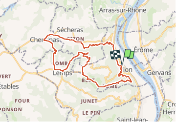

Length
19.3 km

Max alt
467 m

Uphill gradient
668 m
Km-Effort
28 km

Min alt
126 m

Downhill gradient
668 m
Boucle
Yes
Creation date :
2024-03-29 17:50:38.587
Updated on :
2024-03-29 17:51:09.99
4h44
Difficulty : Very difficult

FREE GPS app for hiking
 SityTrail
IGN / Geographical institutes
SityTrail Plus
The world is yours!
About
Trail Walking of 19.3 km to be discovered at Auvergne-Rhône-Alpes, Ardèche, Vion. This trail is proposed by bernardchasson.
Positioning
Country:
France
Region :
Auvergne-Rhône-Alpes
Department/Province :
Ardèche
Municipality :
Vion
Location:
Unknown
Start:(Dec)
Start:(UTM)
642115 ; 4996969 (31T) N.
Comments