


2024-03-30_14h00m04_barrage-ifrane

jpb83
User
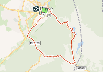

Length
10.6 km

Max alt
1705 m

Uphill gradient
138 m
Km-Effort
12.4 km

Min alt
1632 m

Downhill gradient
138 m
Boucle
Yes
Creation date :
2024-03-30 13:00:04.364
Updated on :
2024-04-01 10:40:36.336
2h49
Difficulty : Very easy
1h05
Difficulty : Easy

FREE GPS app for hiking
 SityTrail
IGN / Geographical institutes
SityTrail Plus
The world is yours!
About
Trail Walking of 10.6 km to be discovered at Fez-Meknes, Pachalik d'Ifrane ⵜⴰⴱⴰⵛⴰⵏⵜ ⵏ ⵉⴼⵔⴰⵏ باشوية إفران, Ifrane. This trail is proposed by jpb83.
Positioning
Country:
Morocco
Region :
Fez-Meknes
Department/Province :
Pachalik d'Ifrane ⵜⴰⴱⴰⵛⴰⵏⵜ ⵏ ⵉⴼⵔⴰⵏ باشوية إفران
Municipality :
Ifrane
Location:
Unknown
Start:(Dec)
Start:(UTM)
303983 ; 3711457 (30S) N.
Comments