


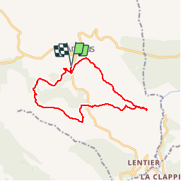
Ampus-L'Englugi-Puy de la Signe

Sugg
User


4h36
Difficulty : Medium

FREE GPS app for hiking
 SityTrail
IGN / Geographical institutes
SityTrail Plus
The world is yours!
About
Trail Walking of 15.9 km to be discovered at Provence-Alpes-Côte d'Azur, Var, Ampus. This trail is proposed by Sugg.
Description
18-03-15
Rando définitive.
La montée au Puy de la Sigue est assez sportif pour les anciens !!!.
Attention à la fin du parcours, à la côte 628 ( Les Gras ) impossible de trouver l'ancienne piste qui contourne la descente directe sur la route afin d'éviter le passage sur une partie privée avec villa, ce jour là, le proprio était sympa. Il faudra affiner cela plus tard !!!
Rappel : le temps indiqué comprend les poses et le pique-nique.
Photos

Positioning
Comments