


SURCENEUX FONIE

surceneux
User
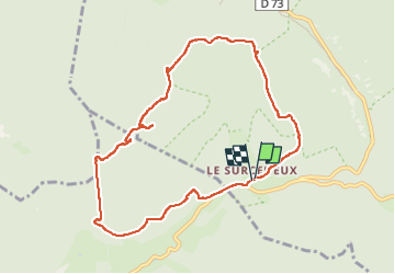

Length
8.9 km

Max alt
1010 m

Uphill gradient
371 m
Km-Effort
13.9 km

Min alt
815 m

Downhill gradient
374 m
Boucle
Yes
Creation date :
2024-03-31 12:38:58.652
Updated on :
2024-03-31 15:13:18.966
2h05
Difficulty : Medium

FREE GPS app for hiking
 SityTrail
IGN / Geographical institutes
SityTrail Plus
The world is yours!
About
Trail Walking of 8.9 km to be discovered at Grand Est, Vosges, Ban-sur-Meurthe-Clefcy. This trail is proposed by surceneux.
Description
SURCENEUX FONIE AR
Positioning
Country:
France
Region :
Grand Est
Department/Province :
Vosges
Municipality :
Ban-sur-Meurthe-Clefcy
Location:
Unknown
Start:(Dec)
Start:(UTM)
347873 ; 5329071 (32U) N.
Comments