


18 km de Menomblet

viaul
User GUIDE
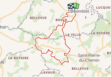

Length
17.3 km

Max alt
224 m

Uphill gradient
251 m
Km-Effort
21 km

Min alt
143 m

Downhill gradient
243 m
Boucle
No
Creation date :
2024-04-01 06:48:01.0
Updated on :
2024-04-01 10:23:45.236

FREE GPS app for hiking
 SityTrail
IGN / Geographical institutes
SityTrail Plus
The world is yours!
About
Trail of 17.3 km to be discovered at Pays de la Loire, Vendée, Menomblet. This trail is proposed by viaul.
Positioning
Country:
France
Region :
Pays de la Loire
Department/Province :
Vendée
Municipality :
Menomblet
Location:
Unknown
Start:(Dec)
Start:(UTM)
674322 ; 5177846 (30T) N.
Comments