


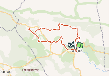
ampus-notre-dame-de-speluque-26-09-2016

clintest
User


FREE GPS app for hiking
 SityTrail
IGN / Geographical institutes
SityTrail Plus
The world is yours!
About
Trail of 17.6 km to be discovered at Provence-Alpes-Côte d'Azur, Var, Ampus. This trail is proposed by clintest.
Description
Randonnée au départ d'Ampus, charmant petit village. Passage par le chemin de croix puis les calades (ça monte), le Turquet, la ferme du Mourjaï, les charbonnières et la chapelle notre dame de Spéluque, le vieux moulin, la source de la Nartuby et le chemin de l'eau.
Positioning
Comments