


SityTrail - Causse Méjean avril 23

Gpoujade
User

Length
41 km

Max alt
1032 m

Uphill gradient
953 m
Km-Effort
53 km

Min alt
777 m

Downhill gradient
952 m
Boucle
Yes
Creation date :
2024-04-02 14:20:05.927
Updated on :
2024-04-08 09:47:25.769
3h42
Difficulty : Very difficult

FREE GPS app for hiking
 SityTrail
IGN / Geographical institutes
SityTrail Plus
The world is yours!
About
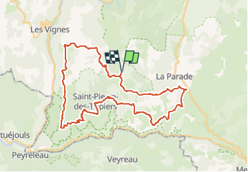
Trail Mountain bike of 41 km to be discovered at Occitania, Lozère, Saint-Pierre-des-Tripiers. This trail is proposed by Gpoujade.
Description
Boucle au départ de La Volpiliére à St Pierre Des Tripieds
Positioning
Country:
France
Region :
Occitania
Department/Province :
Lozère
Municipality :
Saint-Pierre-des-Tripiers
Location:
Unknown
Start:(Dec)
Start:(UTM)
523971 ; 4899373 (31T) N.
Comments