


mes mauves

jpd45650
User
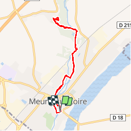

Length
7.4 km

Max alt
103 m

Uphill gradient
46 m
Km-Effort
8 km

Min alt
88 m

Downhill gradient
46 m
Boucle
Yes
Creation date :
2015-03-26 00:00:00.0
Updated on :
2015-03-26 00:00:00.0
2h03
Difficulty : Unknown

FREE GPS app for hiking
 SityTrail
IGN / Geographical institutes
SityTrail Plus
The world is yours!
About
Trail Other activity of 7.4 km to be discovered at Centre-Loire Valley, Loiret, Meung-sur-Loire. This trail is proposed by jpd45650.
Positioning
Country:
France
Region :
Centre-Loire Valley
Department/Province :
Loiret
Municipality :
Meung-sur-Loire
Location:
Unknown
Start:(Dec)
Start:(UTM)
402504 ; 5297610 (31T) N.
Comments