


M'ont ste Odile

jcschubnel
User
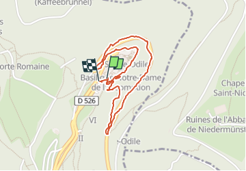

Length
1.9 km

Max alt
769 m

Uphill gradient
60 m
Km-Effort
2.7 km

Min alt
704 m

Downhill gradient
61 m
Boucle
Yes
Creation date :
2023-09-10 12:26:16.32
Updated on :
2024-04-02 16:19:50.111
45m
Difficulty : Easy

FREE GPS app for hiking
 SityTrail
IGN / Geographical institutes
SityTrail Plus
The world is yours!
About
Trail Walking of 1.9 km to be discovered at Grand Est, Bas-Rhin, Ottrott. This trail is proposed by jcschubnel.
Positioning
Country:
France
Region :
Grand Est
Department/Province :
Bas-Rhin
Municipality :
Ottrott
Location:
Unknown
Start:(Dec)
Start:(UTM)
381966 ; 5366115 (32U) N.
Comments