Trail Walking Villiers-sous-Grez - Villiers sous grez / Larchant - Photo

Villiers sous grez / Larchant

 becor94
becor94

User

© OpenStreetMap contributors
Length
Length
24 km
Max alt
Max alt
124 m
Uphill gradient
Uphill gradient
381 m
Km-Effort
Km-Effort  
29 km
Min alt
Min alt
68 m
Downhill gradient
Downhill gradient
383 m
Boucle
Boucle
Yes
Creation date :
2024-04-03 07:42:48.0
Updated on :
2024-04-03 16:51:13.378

(0 Reviews)

Walking
Walking
5h31
Difficulty : Very difficult

Scan this QR Code to open this trail in the SityTrail application

FREE GPS app for hiking

Logo SityTrail SityTrail

IGN / Geographical institutes

Download SityTrail from the App Store Download SityTrail from Google Play

Logo SityTrail SityTrail World

The world is yours!

Download SityTrail from the App Store Download SityTrail from Google Play Download SityTrail on Huawei AppGallery

About

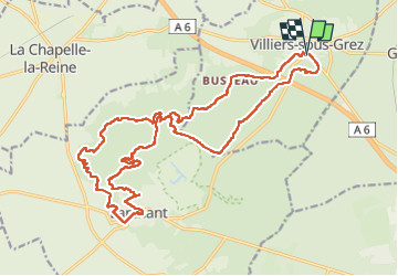
Trail Walking of 24 km to be discovered at Ile-de-France, Seine-et-Marne, Villiers-sous-Grez. This trail is proposed by becor94.

Description

avec Rcy : Christian Pontier  / Murielle

Elevation profile

Photos

Positioning

Country:
France
Region :
Ile-de-France
Department/Province :
Seine-et-Marne
Municipality :
Villiers-sous-Grez
Location:
Unknown
Start:(UTM)
473932 ; 5351556 (31U) N.

Trails nearby

Trail On foot Larchant - Sentier Denecourt-Colinet 19 - Photo
On foot
PRO

On foot

Easy
Larchant, Ile-de-France, Seine-et-Marne, France
9.7 km | 12.3 km-effort
2h 47min
Yes
Trail Walking Recloses - Recloses Ve120124 pm - Photo
Walking
fmg

Walking

Medium
(1)
Recloses, Ile-de-France, Seine-et-Marne, France
8.9 km | 10.5 km-effort
2h 23min
Yes
Trail Walking Recloses - Recloses ve 120124 am - Photo
Walking
fmg

Walking

Medium
(1)
Recloses, Ile-de-France, Seine-et-Marne, France
10.8 km | 12.6 km-effort
2h 52min
Yes
Trail Walking Recloses - Boucle recloses Nemours Grez/loing - Photo
Walking
chessyca

Walking

Medium
(1)
Recloses, Ile-de-France, Seine-et-Marne, France
30 km | 34 km-effort
6h 20min
Yes
Trail Walking Larchant - Larchant la Féérique  - Photo
Walking
chessyca

Walking

Medium
Larchant, Ile-de-France, Seine-et-Marne, France
19.6 km | 24 km-effort
5h 14min
Yes
Trail On foot Bourron-Marlotte - Boucle 30 km Bourron Marlotte - Montigny/ Loing / Grez - Photo
On foot
chessyca

On foot

Difficult
Bourron-Marlotte, Ile-de-France, Seine-et-Marne, France
28 km | 32 km-effort
7h 14min
Yes
Trail Walking Recloses - Recloses Ve 280423 SR30042323 PM10km - Photo
Walking
fmg

Walking

Medium
(1)
Recloses, Ile-de-France, Seine-et-Marne, France
9.9 km | 11.9 km-effort
2h 42min
Yes
Trail Nordic walking Larchant - Dame Juane - Photo
Nordic walking
pierre_mack

Nordic walking

Larchant, Ile-de-France, Seine-et-Marne, France
22 km | 26 km-effort
3h 6min
No
Trail Walking Recloses - Recloses Sentier Denecourt 20 - Photo
Walking
guydu41

Walking

Medium
Recloses, Ile-de-France, Seine-et-Marne, France
6.4 km | 8 km-effort
2h 17min
Yes


Close
My subscriptions