


Mont Falcon Lac Mort. G1

lionelnottat
User
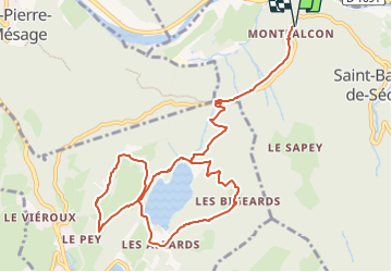

Length
12.7 km

Max alt
1063 m

Uphill gradient
628 m
Km-Effort
21 km

Min alt
544 m

Downhill gradient
628 m
Boucle
Yes
Creation date :
2024-04-04 07:43:22.94
Updated on :
2024-04-04 07:44:40.792
4h47
Difficulty : Very difficult

FREE GPS app for hiking
 SityTrail
IGN / Geographical institutes
SityTrail Plus
The world is yours!
About
Trail Walking of 12.7 km to be discovered at Auvergne-Rhône-Alpes, Isère, Saint-Barthélemy-de-Séchilienne. This trail is proposed by lionelnottat.
Positioning
Country:
France
Region :
Auvergne-Rhône-Alpes
Department/Province :
Isère
Municipality :
Saint-Barthélemy-de-Séchilienne
Location:
Unknown
Start:(Dec)
Start:(UTM)
721246 ; 4992409 (31T) N.
Comments