


cotebelle

Liebeaux
User
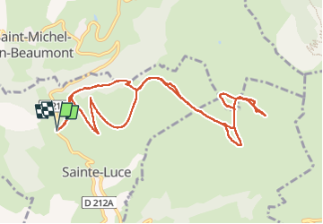

Length
12.3 km

Max alt
1906 m

Uphill gradient
744 m
Km-Effort
22 km

Min alt
1212 m

Downhill gradient
744 m
Boucle
Yes
Creation date :
2024-04-04 07:07:42.474
Updated on :
2024-04-04 13:48:44.618
6h40
Difficulty : Very difficult

FREE GPS app for hiking
 SityTrail
IGN / Geographical institutes
SityTrail Plus
The world is yours!
About
Trail Walking of 12.3 km to be discovered at Auvergne-Rhône-Alpes, Isère, Sainte-Luce. This trail is proposed by Liebeaux.
Positioning
Country:
France
Region :
Auvergne-Rhône-Alpes
Department/Province :
Isère
Municipality :
Sainte-Luce
Location:
Unknown
Start:(Dec)
Start:(UTM)
729488 ; 4971006 (31T) N.
Comments