


Balade Forêt communale de Vauchassis

FPortier
User
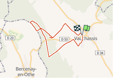

Length
7.5 km

Max alt
259 m

Uphill gradient
121 m
Km-Effort
9.1 km

Min alt
180 m

Downhill gradient
120 m
Boucle
Yes
Creation date :
2024-04-04 12:00:48.56
Updated on :
2024-04-04 14:27:19.122
2h26
Difficulty : Medium

FREE GPS app for hiking
 SityTrail
IGN / Geographical institutes
SityTrail Plus
The world is yours!
About
Trail Walking of 7.5 km to be discovered at Grand Est, Aube, Vauchassis. This trail is proposed by FPortier.
Description
Balade vauchassis 7 kms
Photos


Positioning
Country:
France
Region :
Grand Est
Department/Province :
Aube
Municipality :
Vauchassis
Location:
Unknown
Start:(Dec)
Start:(UTM)
568493 ; 5341417 (31U) N.
Comments