


VALSAIRES CHAPELLE NOTRE DAME DU LAIS

RobinMicheline
User GUIDE
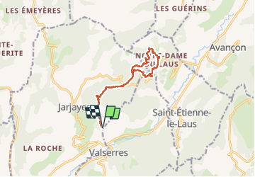

Length
14.2 km

Max alt
1131 m

Uphill gradient
643 m
Km-Effort
23 km

Min alt
729 m

Downhill gradient
641 m
Boucle
Yes
Creation date :
2024-04-04 07:41:14.119
Updated on :
2024-04-04 14:28:02.901
4h25
Difficulty : Difficult

FREE GPS app for hiking
 SityTrail
IGN / Geographical institutes
SityTrail Plus
The world is yours!
About
Trail Walking of 14.2 km to be discovered at Provence-Alpes-Côte d'Azur, Hautes-Alpes, Jarjayes. This trail is proposed by RobinMicheline.
Photos


Positioning
Country:
France
Region :
Provence-Alpes-Côte d'Azur
Department/Province :
Hautes-Alpes
Municipality :
Jarjayes
Location:
Unknown
Start:(Dec)
Start:(UTM)
271413 ; 4931116 (32T) N.
Comments