


Château-Thierry les Blanchards-Rando-Santé du 05-04-2024

VANDERPUTTENMi
User GUIDE
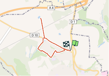

Length
5.5 km

Max alt
219 m

Uphill gradient
57 m
Km-Effort
6.3 km

Min alt
197 m

Downhill gradient
56 m
Boucle
Yes
Creation date :
2024-04-05 11:39:07.142
Updated on :
2024-04-07 17:32:17.736
1h42
Difficulty : Medium

FREE GPS app for hiking
 SityTrail
IGN / Geographical institutes
SityTrail Plus
The world is yours!
About
Trail Walking of 5.5 km to be discovered at Hauts-de-France, Aisne, Château-Thierry. This trail is proposed by VANDERPUTTENMi.
Photos

Positioning
Country:
France
Region :
Hauts-de-France
Department/Province :
Aisne
Municipality :
Château-Thierry
Location:
Unknown
Start:(Dec)
Start:(UTM)
528747 ; 5434432 (31U) N.
Comments