Trail On foot Caussols - caussols club 2  notre dame de calern - Photo

caussols club 2 notre dame de calern

 clintest
clintest

User

© OpenStreetMap contributors
Length
Length
20 km
Max alt
Max alt
1447 m
Uphill gradient
Uphill gradient
623 m
Km-Effort
Km-Effort  
29 km
Min alt
Min alt
1074 m
Downhill gradient
Downhill gradient
626 m
Boucle
Boucle
Yes
Creation date :
2024-04-06 08:22:08.082
Updated on :
2024-04-06 08:24:17.963

(0 Reviews)

On foot
On foot
6h32
Difficulty : Medium

Scan this QR Code to open this trail in the SityTrail application

FREE GPS app for hiking

Logo SityTrail SityTrail

IGN / Geographical institutes

Download SityTrail from the App Store Download SityTrail from Google Play

Logo SityTrail SityTrail Plus

The world is yours!

Download SityTrail from the App Store Download SityTrail from Google Play Download SityTrail on Huawei AppGallery

About

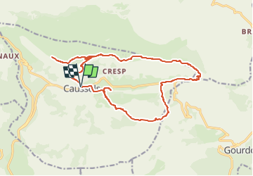
Trail On foot of 20 km to be discovered at Provence-Alpes-Côte d'Azur, Maritime Alps, Caussols. This trail is proposed by clintest.

Description

depart de la mairie 1100 M environ vers notre dame de calern puis le sommet de caler 1458 m retour vers l observatoire puis la voie romaine _ la bergerie de maubert l embut de caussols et retour parking mairie caussols

Elevation profile

Positioning

Country:
France
Region :
Provence-Alpes-Côte d'Azur
Department/Province :
Maritime Alps
Municipality :
Caussols
Location:
Unknown
Start:(UTM)
330892 ; 4845339 (32T) N.


Close
My subscriptions