


vianden

aucamus
User
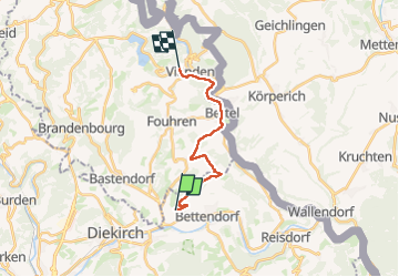

Length
12.5 km

Max alt
437 m

Uphill gradient
335 m
Km-Effort
17 km

Min alt
195 m

Downhill gradient
366 m
Boucle
No
Creation date :
2024-04-06 12:22:10.781
Updated on :
2024-04-06 15:11:16.501
2h48
Difficulty : Difficult

FREE GPS app for hiking
 SityTrail
IGN / Geographical institutes
SityTrail Plus
The world is yours!
About
Trail Walking of 12.5 km to be discovered at Unknown, Canton Diekirch, Bettendorf. This trail is proposed by aucamus.
Positioning
Country:
Luxembourg
Region :
Unknown
Department/Province :
Canton Diekirch
Municipality :
Bettendorf
Location:
Unknown
Start:(Dec)
Start:(UTM)
298680 ; 5528876 (32U) N.
Comments