


Triors

meillon
User
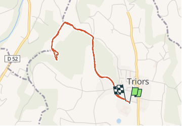

Length
4.4 km

Max alt
324 m

Uphill gradient
129 m
Km-Effort
6.1 km

Min alt
209 m

Downhill gradient
122 m
Boucle
Yes
Creation date :
2024-04-06 13:46:30.472
Updated on :
2024-04-06 15:26:57.466
1h40
Difficulty : Medium

FREE GPS app for hiking
 SityTrail
IGN / Geographical institutes
SityTrail Plus
The world is yours!
About
Trail Walking of 4.4 km to be discovered at Auvergne-Rhône-Alpes, Drôme, Triors. This trail is proposed by meillon.
Description
à partir de l abbaye promenade sur les hauteurs jusqu à un ancien camp scout ? vue sur les moucherolles et le Veymont
Positioning
Country:
France
Region :
Auvergne-Rhône-Alpes
Department/Province :
Drôme
Municipality :
Triors
Location:
Unknown
Start:(Dec)
Start:(UTM)
666330 ; 4995666 (31T) N.
Comments