


Marigny-en-Orxois du 07-04-2024

VANDERPUTTENMi
User GUIDE
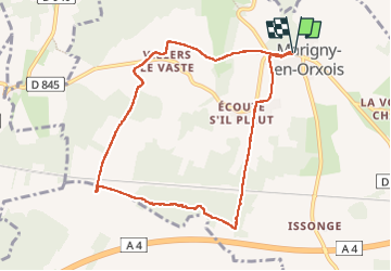

Length
8.3 km

Max alt
216 m

Uphill gradient
138 m
Km-Effort
10.2 km

Min alt
122 m

Downhill gradient
139 m
Boucle
Yes
Creation date :
2024-04-07 07:02:14.182
Updated on :
2024-04-07 17:44:11.287
2h15
Difficulty : Medium

FREE GPS app for hiking
 SityTrail
IGN / Geographical institutes
SityTrail Plus
The world is yours!
About
Trail Walking of 8.3 km to be discovered at Hauts-de-France, Aisne, Marigny-en-Orxois. This trail is proposed by VANDERPUTTENMi.
Photos


Positioning
Country:
France
Region :
Hauts-de-France
Department/Province :
Aisne
Municipality :
Marigny-en-Orxois
Location:
Unknown
Start:(Dec)
Start:(UTM)
516551 ; 5434171 (31U) N.
Comments