


Bairols mont Falourde

Christine460600
User
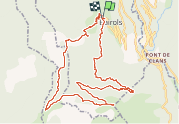

Length
14.4 km

Max alt
1286 m

Uphill gradient
732 m
Km-Effort
24 km

Min alt
792 m

Downhill gradient
746 m
Boucle
Yes
Creation date :
2024-04-07 06:56:01.256
Updated on :
2024-04-07 13:24:17.108
4h15
Difficulty : Medium

FREE GPS app for hiking
 SityTrail
IGN / Geographical institutes
SityTrail Plus
The world is yours!
About
Trail Walking of 14.4 km to be discovered at Provence-Alpes-Côte d'Azur, Maritime Alps, Bairols. This trail is proposed by Christine460600.
Positioning
Country:
France
Region :
Provence-Alpes-Côte d'Azur
Department/Province :
Maritime Alps
Municipality :
Bairols
Location:
Unknown
Start:(Dec)
Start:(UTM)
349633 ; 4871719 (32T) N.
Comments