


Bairols - Mont Falourde

GeorgesV.
User
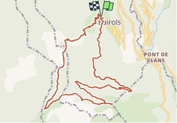

Length
14.5 km

Max alt
1291 m

Uphill gradient
731 m
Km-Effort
24 km

Min alt
792 m

Downhill gradient
731 m
Boucle
Yes
Creation date :
2024-04-07 06:56:21.0
Updated on :
2024-04-10 17:16:20.177
5h30
Difficulty : Very difficult

FREE GPS app for hiking
 SityTrail
IGN / Geographical institutes
SityTrail Plus
The world is yours!
About
Trail Walking of 14.5 km to be discovered at Provence-Alpes-Côte d'Azur, Maritime Alps, Bairols. This trail is proposed by GeorgesV..
Positioning
Country:
France
Region :
Provence-Alpes-Côte d'Azur
Department/Province :
Maritime Alps
Municipality :
Bairols
Location:
Unknown
Start:(Dec)
Start:(UTM)
349635 ; 4871718 (32T) N.
Comments