


2025 Queyras J01

Airelle
User

Length
10.3 km

Max alt
2942 m

Uphill gradient
1283 m
Km-Effort
23 km

Min alt
1673 m

Downhill gradient
50 m
Boucle
No
Creation date :
2024-04-09 18:41:44.909
Updated on :
2025-03-22 16:38:57.731
5h18
Difficulty : Very difficult

FREE GPS app for hiking
 SityTrail
IGN / Geographical institutes
SityTrail Plus
The world is yours!
About
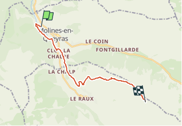
Trail Walking of 10.3 km to be discovered at Provence-Alpes-Côte d'Azur, Hautes-Alpes, Molines-en-Queyras. This trail is proposed by Airelle.
Positioning
Country:
France
Region :
Provence-Alpes-Côte d'Azur
Department/Province :
Hautes-Alpes
Municipality :
Molines-en-Queyras
Location:
Unknown
Start:(Dec)
Start:(UTM)
328612 ; 4955611 (32T) N.
Comments