


2025 Queyras J04

Airelle
User

Length
12.8 km

Max alt
3065 m

Uphill gradient
525 m
Km-Effort
23 km

Min alt
1662 m

Downhill gradient
1437 m
Boucle
No
Creation date :
2024-04-09 18:59:47.661
Updated on :
2025-02-27 11:46:05.192
5h11
Difficulty : Very difficult

FREE GPS app for hiking
 SityTrail
IGN / Geographical institutes
SityTrail Plus
The world is yours!
About
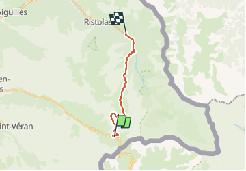
Trail Walking of 12.8 km to be discovered at Provence-Alpes-Côte d'Azur, Hautes-Alpes, Molines-en-Queyras. This trail is proposed by Airelle.
Positioning
Country:
France
Region :
Provence-Alpes-Côte d'Azur
Department/Province :
Hautes-Alpes
Municipality :
Molines-en-Queyras
Location:
Unknown
Start:(Dec)
Start:(UTM)
339274 ; 4950700 (32T) N.
Comments