


ver sur lunette essai

APhilippe
User
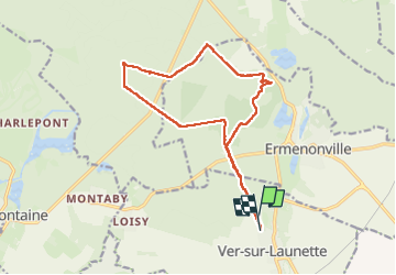

Length
14.7 km

Max alt
120 m

Uphill gradient
177 m
Km-Effort
17 km

Min alt
84 m

Downhill gradient
178 m
Boucle
No
Creation date :
2024-04-10 07:07:50.08
Updated on :
2024-04-10 10:10:57.761
3h02
Difficulty : Very easy

FREE GPS app for hiking
 SityTrail
IGN / Geographical institutes
SityTrail Plus
The world is yours!
About
Trail Nordic walking of 14.7 km to be discovered at Hauts-de-France, Oise, Ver-sur-Launette. This trail is proposed by APhilippe.
Positioning
Country:
France
Region :
Hauts-de-France
Department/Province :
Oise
Municipality :
Ver-sur-Launette
Location:
Unknown
Start:(Dec)
Start:(UTM)
476649 ; 5439845 (31U) N.
Comments