


vat1036L1 - Vallon de Cabane

jmheydorff
User
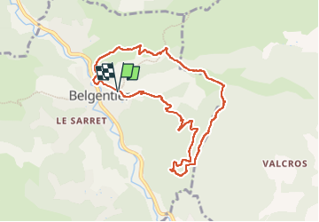

Length
9.2 km

Max alt
428 m

Uphill gradient
385 m
Km-Effort
14.3 km

Min alt
160 m

Downhill gradient
380 m
Boucle
Yes
Creation date :
2024-04-10 07:06:58.735
Updated on :
2024-04-10 16:21:53.568
3h14
Difficulty : Difficult

FREE GPS app for hiking
 SityTrail
IGN / Geographical institutes
SityTrail Plus
The world is yours!
About
Trail Walking of 9.2 km to be discovered at Provence-Alpes-Côte d'Azur, Var, Belgentier. This trail is proposed by jmheydorff.
Positioning
Country:
France
Region :
Provence-Alpes-Côte d'Azur
Department/Province :
Var
Municipality :
Belgentier
Location:
Unknown
Start:(Dec)
Start:(UTM)
256770 ; 4792463 (32T) N.
Comments