


Nans - L’Huveaune

GeorgesV.
User
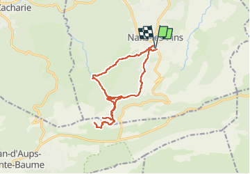

Length
16 km

Max alt
709 m

Uphill gradient
591 m
Km-Effort
24 km

Min alt
394 m

Downhill gradient
591 m
Boucle
Yes
Creation date :
2024-04-10 06:48:05.0
Updated on :
2024-04-10 17:15:00.176
5h25
Difficulty : Very difficult

FREE GPS app for hiking
 SityTrail
IGN / Geographical institutes
SityTrail Plus
The world is yours!
About
Trail Walking of 16 km to be discovered at Provence-Alpes-Côte d'Azur, Var, Nans-les-Pins. This trail is proposed by GeorgesV..
Positioning
Country:
France
Region :
Provence-Alpes-Côte d'Azur
Department/Province :
Var
Municipality :
Nans-les-Pins
Location:
Unknown
Start:(Dec)
Start:(UTM)
725596 ; 4805588 (31T) N.
Comments