


2024-04-10_19h26m57_B21 1 (1)

LUTZMarc
User
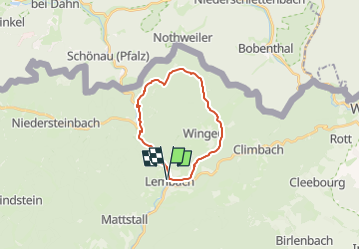

Length
17.7 km

Max alt
375 m

Uphill gradient
437 m
Km-Effort
23 km

Min alt
193 m

Downhill gradient
437 m
Boucle
Yes
Creation date :
2024-04-10 17:26:57.455
Updated on :
2024-11-01 08:38:26.793
5h20
Difficulty : Medium

FREE GPS app for hiking
 SityTrail
IGN / Geographical institutes
SityTrail Plus
The world is yours!
About
Trail Walking of 17.7 km to be discovered at Grand Est, Bas-Rhin, Lembach. This trail is proposed by LUTZMarc.
Positioning
Country:
France
Region :
Grand Est
Department/Province :
Bas-Rhin
Municipality :
Lembach
Location:
Unknown
Start:(Dec)
Start:(UTM)
411393 ; 5428652 (32U) N.
Comments