


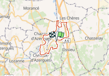
Marcilly, Civrieux, Chazay, Les Chères

daniellebou
User

Length
12.5 km

Max alt
265 m

Uphill gradient
177 m
Km-Effort
14.9 km

Min alt
181 m

Downhill gradient
177 m
Boucle
Yes
Creation date :
2024-04-11 11:16:11.089
Updated on :
2024-04-11 11:16:14.354
3h22
Difficulty : Difficult

FREE GPS app for hiking
 SityTrail
IGN / Geographical institutes
SityTrail Plus
The world is yours!
About
Trail Walking of 12.5 km to be discovered at Auvergne-Rhône-Alpes, Rhône, Marcilly-d'Azergues. This trail is proposed by daniellebou.
Positioning
Country:
France
Region :
Auvergne-Rhône-Alpes
Department/Province :
Rhône
Municipality :
Marcilly-d'Azergues
Location:
Unknown
Start:(Dec)
Start:(UTM)
634190 ; 5081235 (31T) N.
Comments
Super balade