


La Rivière Planfoy

psesjs
User
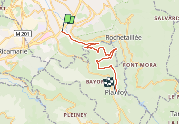

Length
10.2 km

Max alt
994 m

Uphill gradient
491 m
Km-Effort
15.5 km

Min alt
571 m

Downhill gradient
117 m
Boucle
No
Creation date :
2024-04-11 10:51:03.325
Updated on :
2024-04-11 11:57:10.945
1h05
Difficulty : Easy

FREE GPS app for hiking
 SityTrail
IGN / Geographical institutes
SityTrail Plus
The world is yours!
About
Trail Mountain bike of 10.2 km to be discovered at Auvergne-Rhône-Alpes, Loire, Saint-Étienne. This trail is proposed by psesjs.
Positioning
Country:
France
Region :
Auvergne-Rhône-Alpes
Department/Province :
Loire
Municipality :
Saint-Étienne
Location:
Unknown
Start:(Dec)
Start:(UTM)
609823 ; 5029874 (31T) N.
Comments