


traversé de la Drôme par hexatrek etp1

taguette
User
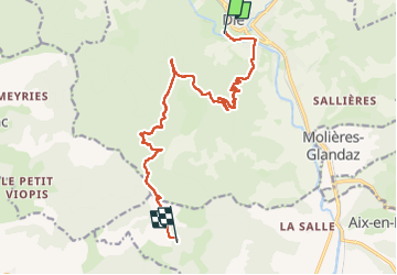

Length
14.5 km

Max alt
1224 m

Uphill gradient
943 m
Km-Effort
25 km

Min alt
395 m

Downhill gradient
182 m
Boucle
No
Creation date :
2024-04-11 09:16:12.389
Updated on :
2024-04-11 15:45:52.778
6h29
Difficulty : Difficult

FREE GPS app for hiking
 SityTrail
IGN / Geographical institutes
SityTrail Plus
The world is yours!
About
Trail Walking of 14.5 km to be discovered at Auvergne-Rhône-Alpes, Drôme, Die. This trail is proposed by taguette.
Positioning
Country:
France
Region :
Auvergne-Rhône-Alpes
Department/Province :
Drôme
Municipality :
Die
Location:
Unknown
Start:(Dec)
Start:(UTM)
687301 ; 4957943 (31T) N.
Comments