


GR364-Jour n° 9

dudu79
User

Length
27 km

Max alt
62 m

Uphill gradient
288 m
Km-Effort
30 km

Min alt
8 m

Downhill gradient
312 m
Boucle
No
Creation date :
2024-04-12 06:34:49.492
Updated on :
2024-04-13 05:35:17.986
6h55
Difficulty : Very difficult

FREE GPS app for hiking
 SityTrail
IGN / Geographical institutes
SityTrail Plus
The world is yours!
About
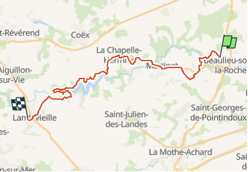
Trail Walking of 27 km to be discovered at Pays de la Loire, Vendée, Beaulieu-sous-la-Roche. This trail is proposed by dudu79.
Positioning
Country:
France
Region :
Pays de la Loire
Department/Province :
Vendée
Municipality :
Beaulieu-sous-la-Roche
Location:
Unknown
Start:(Dec)
Start:(UTM)
605526 ; 5170857 (30T) N.
Comments