


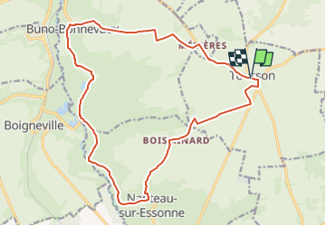
Tousson - Buno-Bonnevaux - Nanteau-sur-Essonne

mathis01
User

Length
19 km

Max alt
133 m

Uphill gradient
146 m
Km-Effort
21 km

Min alt
66 m

Downhill gradient
146 m
Boucle
Yes
Creation date :
2024-04-12 10:00:04.224
Updated on :
2024-05-12 19:04:04.922
4h45
Difficulty : Medium

FREE GPS app for hiking
 SityTrail
IGN / Geographical institutes
SityTrail Plus
The world is yours!
About
Trail On foot of 19 km to be discovered at Ile-de-France, Seine-et-Marne, Tousson. This trail is proposed by mathis01.
Positioning
Country:
France
Region :
Ile-de-France
Department/Province :
Seine-et-Marne
Municipality :
Tousson
Location:
Unknown
Start:(Dec)
Start:(UTM)
459744 ; 5354984 (31U) N.
Comments