


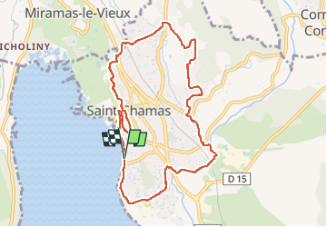
St Chamas - sentier du patrimoine

mhetpierre
User

Length
10.3 km

Max alt
96 m

Uphill gradient
188 m
Km-Effort
12.8 km

Min alt
0 m

Downhill gradient
189 m
Boucle
Yes
Creation date :
2024-04-12 08:57:47.0
Updated on :
2024-04-24 16:31:29.782
2h55
Difficulty : Difficult

FREE GPS app for hiking
 SityTrail
IGN / Geographical institutes
SityTrail Plus
The world is yours!
About
Trail Walking of 10.3 km to be discovered at Provence-Alpes-Côte d'Azur, Bouches-du-Rhône, Saint-Chamas. This trail is proposed by mhetpierre.
Positioning
Country:
France
Region :
Provence-Alpes-Côte d'Azur
Department/Province :
Bouches-du-Rhône
Municipality :
Saint-Chamas
Location:
Unknown
Start:(Dec)
Start:(UTM)
664278 ; 4823153 (31T) N.
Comments