


Saint Genest Sebet Haut

pb07
User
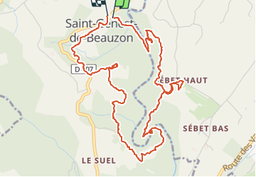

Length
6.5 km

Max alt
279 m

Uphill gradient
146 m
Km-Effort
8.5 km

Min alt
207 m

Downhill gradient
142 m
Boucle
Yes
Creation date :
2024-04-12 12:39:57.915
Updated on :
2024-04-12 14:33:26.728
1h52
Difficulty : Medium

FREE GPS app for hiking
 SityTrail
IGN / Geographical institutes
SityTrail Plus
The world is yours!
About
Trail Walking of 6.5 km to be discovered at Auvergne-Rhône-Alpes, Ardèche, Saint-Genest-de-Beauzon. This trail is proposed by pb07.
Positioning
Country:
France
Region :
Auvergne-Rhône-Alpes
Department/Province :
Ardèche
Municipality :
Saint-Genest-de-Beauzon
Location:
Unknown
Start:(Dec)
Start:(UTM)
594606 ; 4923121 (31T) N.
Comments