


Gorges d'Oppedette

soca
User
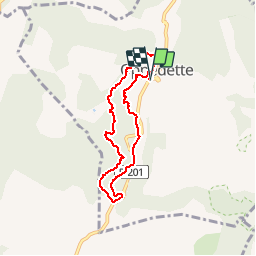

Length
6.3 km

Max alt
532 m

Uphill gradient
212 m
Km-Effort
9.1 km

Min alt
414 m

Downhill gradient
215 m
Boucle
Yes
Creation date :
2015-03-29 00:00:00.0
Updated on :
2015-03-29 00:00:00.0
2h06
Difficulty : Medium

FREE GPS app for hiking
 SityTrail
IGN / Geographical institutes
SityTrail Plus
The world is yours!
About
Trail Walking of 6.3 km to be discovered at Provence-Alpes-Côte d'Azur, Alpes-de-Haute-Provence, Oppedette. This trail is proposed by soca.
Positioning
Country:
France
Region :
Provence-Alpes-Côte d'Azur
Department/Province :
Alpes-de-Haute-Provence
Municipality :
Oppedette
Location:
Unknown
Start:(Dec)
Start:(UTM)
707926 ; 4867774 (31T) N.
Comments