Trail Nordic walking Zafra - villafranca - Photo
© OpenStreetMap contributors
Length
Length
16.7 km
Max alt
Max alt
615 m
Uphill gradient
Uphill gradient
196 m
Km-Effort
Km-Effort  
19.6 km
Min alt
Min alt
440 m
Downhill gradient
Downhill gradient
280 m
Boucle
Boucle
No
Creation date :
2024-04-13 05:47:33.038
Updated on :
2024-04-13 10:42:35.421

(0 Reviews)

Nordic walking
Nordic walking
4h44
Difficulty : Very easy

Scan this QR Code to open this trail in the SityTrail application

FREE GPS app for hiking

Logo SityTrail SityTrail

IGN / Geographical institutes

Download SityTrail from the App Store Download SityTrail from Google Play

Logo SityTrail SityTrail World

The world is yours!

Download SityTrail from the App Store Download SityTrail from Google Play Download SityTrail on Huawei AppGallery

About

Trail Nordic walking of 16.7 km to be discovered at Extremadura, Badajoz, Zafra. This trail is proposed by suzanne.bron.

Elevation profile

Photos

Positioning

Country:
Spain
Region :
Extremadura
Department/Province :
Badajoz
Municipality :
Zafra
Location:
Unknown
Start:(UTM)
725993 ; 4256163 (29S) N.

Trails nearby

Trail Walking  - Zafra  - Photo
Walking
suzanne.bron

Walking

Easy
, Extremadura, Badajoz, Spain
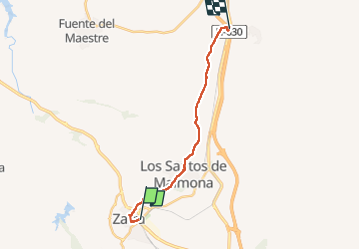
1.2 km | 1.2 km-effort
31min
No
Trail Other activity  - Compostelle 2 villafranca de los baros - Photo
Other activity
eric1955

Other activity

Very easy
, Extremadura, Badajoz, Spain
20 km | 24 km-effort
4h 47min
No
Trail Walking  - 2015 05 23 zafra à villafranca de los barros - Photo
Walking
vsellier

Walking

Very easy
, Extremadura, Badajoz, Spain
20 km | 24 km-effort
4h 46min
No


Close
My subscriptions