![](/images/other/stat-length.png)
![Trail Walking Cauterets - Boucle Cauterets - col de Riou - col de Lisey - Cauterets (par la Soum des Aulhères) - Photo](https://media.geolcdn.com/t/1900/400/ext.pjpeg?maxdim=2&url=https%3A%2F%2Fstatic1.geolcdn.com%2Fsiteimages%2Fupload%2Ffiles%2F1553511878bg_sport_marche.png)
Boucle Cauterets - col de Riou - col de Lisey - Cauterets (par la Soum des Aulhères)
Alokteff
User
![Length](/images/other/stat-length.png)
Length
17.8 km
![Max alt](https://static1.geolcdn.com/siteimages/upload/files/1508320355ic_sort_altitude_max_24dp.png)
Max alt
2160 m
![Uphill gradient](https://static1.geolcdn.com/siteimages/upload/files/1508320355ic_sort_den_pos_24dp.png)
Uphill gradient
1249 m
![Km-Effort](/images/other/stat-length.png)
Km-Effort
34 km
![Min alt](https://static1.geolcdn.com/siteimages/upload/files/1508320355ic_sort_altitude_min_24dp.png)
Min alt
944 m
![Downhill gradient](https://static1.geolcdn.com/siteimages/upload/files/1508320355ic_sort_den_neg_24dp.png)
Downhill gradient
1247 m
![Boucle](https://static1.geolcdn.com/siteimages/upload/files/16400158638029165_repeat_loop_refresh_sync_direction_icon.png)
Boucle
Yes
Creation date :
2024-04-13 07:36:48.813
Updated on :
2024-04-13 14:44:26.009
![Walking](https://static1.geolcdn.com/sitytour/trail-icons/101.png)
5h11
Difficulty : Difficult
![Scan this QR Code to open this trail in the SityTrail application](https://capi.geolives.com/qq0zvz2zws4bq2lad0pu/sitytour/trails/4014978/qr.png?size=200)
FREE GPS app for hiking
About
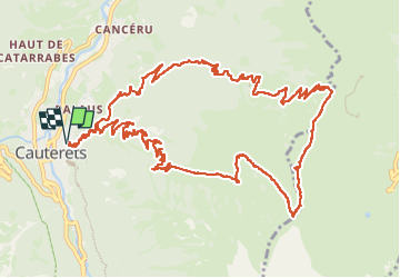
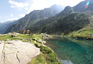
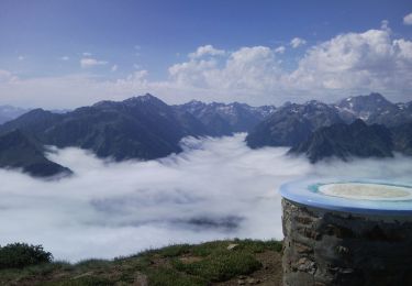
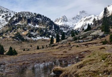
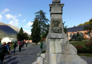
Trail Walking of 17.8 km to be discovered at Occitania, Hautespyrenees, Cauterets. This trail is proposed by Alokteff.
Description
Initialement prévue en raquettes, elle s'est finalement transformée en pédestre. Attention à l'attaque de la descente du col de Lisey s'il reste de la neige, car c'est déversant.
Positioning
Country:
France
Region :
Occitania
Department/Province :
Hautespyrenees
Municipality :
Cauterets
Location:
Unknown
Start:(Dec)
Start:(UTM)
735828 ; 4752697 (30T) N.
Comments
Trails nearby
![Trail Walking Cauterets - Lac d'Estom - Photo](https://media.geolcdn.com/t/375/260/ext.jpg?maxdim=2&url=https%3A%2F%2Fmedia.geolcdn.com%2Ff%2F7676879f-23b9-4413-a840-ce71b34895f9.jpg)
![Walking Walking](https://static1.geolcdn.com/sitytour/trail-icons/101.png)
Lac d'Estom
Walking
Medium
(1)
Cauterets,
Occitania,
Hautespyrenees,
France
![](/images/other/stat-length.png)
11.4 km | 17.5 km-effort
3h 30min
![](https://static1.geolcdn.com/siteimages/upload/files/16400158638029165_repeat_loop_refresh_sync_direction_icon.png)
Yes
![Trail Walking Cauterets - contrefort de Cauterets - Photo](https://media.geolcdn.com/t/375/260/ext.jpg?maxdim=2&url=https%3A%2F%2Fservices.sitytrail.com%2FGeolivesWS%2FDownloadMedia.ashx%3FTrailID%3D397347%26Media%3Dfix__20150318161219.jpg)
![Walking Walking](https://static1.geolcdn.com/sitytour/trail-icons/101.png)
contrefort de Cauterets
Walking
Medium
(1)
Cauterets,
Occitania,
Hautespyrenees,
France
![](/images/other/stat-length.png)
13.7 km | 21 km-effort
4h 21min
![](https://static1.geolcdn.com/siteimages/upload/files/16400158638029165_repeat_loop_refresh_sync_direction_icon.png)
Yes
![Trail Walking Grust - PIC DE VISCOS - Photo](https://media.geolcdn.com/t/375/260/ext.jpg?maxdim=2&url=https%3A%2F%2Fservices.sitytrail.com%2FGeolivesWS%2FDownloadMedia.ashx%3FTrailID%3D330339%26Media%3Dfix__20140802123956.jpg)
![Walking Walking](https://static1.geolcdn.com/sitytour/trail-icons/101.png)
PIC DE VISCOS
Walking
Medium
(1)
Grust,
Occitania,
Hautespyrenees,
France
![](/images/other/stat-length.png)
10.5 km | 18.4 km-effort
4h 7min
![](https://static1.geolcdn.com/siteimages/upload/files/16400158638029165_repeat_loop_refresh_sync_direction_icon.png)
Yes
![Trail Walking Cauterets - Le Cabaliros - Photo](https://media.geolcdn.com/t/375/260/ext.jpg?maxdim=2&url=https%3A%2F%2Fservices.sitytrail.com%2FGeolivesWS%2FDownloadMedia.ashx%3FTrailID%3D103561%26Media%3D5820_5.jpg)
![Walking Walking](https://static1.geolcdn.com/sitytour/trail-icons/101.png)
Le Cabaliros
Walking
Difficult
(1)
Cauterets,
Occitania,
Hautespyrenees,
France
![](/images/other/stat-length.png)
14.5 km | 29 km-effort
5h 0min
![](https://static1.geolcdn.com/siteimages/upload/files/16400158638029165_repeat_loop_refresh_sync_direction_icon.png)
Yes
![Trail Walking Cauterets - promenade Russell - Photo](https://media.geolcdn.com/t/375/260/ext.jpg?maxdim=2&url=https%3A%2F%2Fservices.sitytrail.com%2FGeolivesWS%2FDownloadMedia.ashx%3FTrailID%3D1020841%26Media%3Dfix__20180812100734.jpg)
![Walking Walking](https://static1.geolcdn.com/sitytour/trail-icons/101.png)
promenade Russell
Walking
Very easy
(1)
Cauterets,
Occitania,
Hautespyrenees,
France
![](/images/other/stat-length.png)
11.9 km | 21 km-effort
5h 46min
![](https://static1.geolcdn.com/siteimages/upload/files/16400158638029165_repeat_loop_refresh_sync_direction_icon.png)
Yes
![Trail Walking Cauterets - Chemin des cascades - Photo](https://media.geolcdn.com/t/375/260/ext.jpg?maxdim=2&url=https%3A%2F%2Fservices.sitytrail.com%2FGeolivesWS%2FDownloadMedia.ashx%3FTrailID%3D807444%26Media%3Dfix__20170811162357.jpg)
![Walking Walking](https://static1.geolcdn.com/sitytour/trail-icons/101.png)
Chemin des cascades
Walking
Easy
(1)
Cauterets,
Occitania,
Hautespyrenees,
France
![](/images/other/stat-length.png)
8 km | 12.6 km-effort
2h 30min
![](https://static1.geolcdn.com/siteimages/upload/files/16400158638029165_repeat_loop_refresh_sync_direction_icon.png)
No
![Trail Walking Cauterets - 2022-12-31 Marche Refuge du Clot vers Refuge Wallon - Photo](https://media.geolcdn.com/t/375/260/ext.jpg?maxdim=2&url=https%3A%2F%2Fmedia.geolcdn.com%2Ff%2Fb3b3e7b5-b7c0-4d24-bf3e-ca9e2bad9ac8.jpg)
![Walking Walking](https://static1.geolcdn.com/sitytour/trail-icons/101.png)
2022-12-31 Marche Refuge du Clot vers Refuge Wallon
Walking
Difficult
Cauterets,
Occitania,
Hautespyrenees,
France
![](/images/other/stat-length.png)
17.3 km | 34 km-effort
7h 46min
![](https://static1.geolcdn.com/siteimages/upload/files/16400158638029165_repeat_loop_refresh_sync_direction_icon.png)
No
![Trail Walking Cauterets - CAUTERETS Le chemin des pères G3 le 14/10/2022](https://media.geolcdn.com/t/375/260/ext.jpg?maxdim=2&url=https%3A%2F%2Fmedia.geolcdn.com%2Ff%2F15fc21f1-76b1-44b0-aa82-d95bc69ee2d3.jpg)
![Walking Walking](https://static1.geolcdn.com/sitytour/trail-icons/101.png)
CAUTERETS Le chemin des pères G3 le 14/10/2022 "3423761"
Walking
Medium
Cauterets,
Occitania,
Hautespyrenees,
France
![](/images/other/stat-length.png)
9.4 km | 15.3 km-effort
3h 5min
![](https://static1.geolcdn.com/siteimages/upload/files/16400158638029165_repeat_loop_refresh_sync_direction_icon.png)
Yes
![Trail Walking Cauterets - Pic d'Estibe Aute - Photo](https://media.geolcdn.com/t/375/260/ext.jpg?maxdim=2&url=https%3A%2F%2Fstatic1.geolcdn.com%2Fsiteimages%2Fupload%2Ffiles%2F1553511878bg_sport_marche.png)
![Walking Walking](https://static1.geolcdn.com/sitytour/trail-icons/101.png)
Pic d'Estibe Aute
Walking
Very difficult
(1)
Cauterets,
Occitania,
Hautespyrenees,
France
![](/images/other/stat-length.png)
17.2 km | 36 km-effort
7h 0min
![](https://static1.geolcdn.com/siteimages/upload/files/16400158638029165_repeat_loop_refresh_sync_direction_icon.png)
Yes