


Saint Odile reel BS

bstebe
User
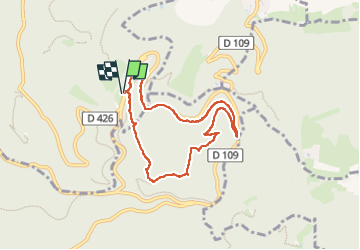

Length
7.1 km

Max alt
825 m

Uphill gradient
245 m
Km-Effort
10.4 km

Min alt
624 m

Downhill gradient
244 m
Boucle
Yes
Creation date :
2024-04-13 11:40:55.493
Updated on :
2024-04-14 04:07:55.746
2h19
Difficulty : Medium

FREE GPS app for hiking
 SityTrail
IGN / Geographical institutes
SityTrail Plus
The world is yours!
About
Trail Walking of 7.1 km to be discovered at Grand Est, Bas-Rhin, Ottrott. This trail is proposed by bstebe.
Positioning
Country:
France
Region :
Grand Est
Department/Province :
Bas-Rhin
Municipality :
Ottrott
Location:
Unknown
Start:(Dec)
Start:(UTM)
381725 ; 5365798 (32U) N.
Comments