


Boucle Figanieres

papyduck
User
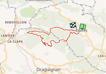

Length
14.9 km

Max alt
549 m

Uphill gradient
424 m
Km-Effort
21 km

Min alt
312 m

Downhill gradient
422 m
Boucle
Yes
Creation date :
2024-04-14 09:06:34.366
Updated on :
2024-04-14 13:33:59.885
3h37
Difficulty : Very difficult

FREE GPS app for hiking
 SityTrail
IGN / Geographical institutes
SityTrail Plus
The world is yours!
About
Trail Walking of 14.9 km to be discovered at Provence-Alpes-Côte d'Azur, Var, Figanières. This trail is proposed by papyduck.
Description
Belle randonné mais la température déjà haute....
Photos


Positioning
Country:
France
Region :
Provence-Alpes-Côte d'Azur
Department/Province :
Var
Municipality :
Figanières
Location:
Unknown
Start:(Dec)
Start:(UTM)
297976 ; 4826929 (32T) N.
Comments
Superbe randonnée d'automne.