


le trou au loup

cousam
User
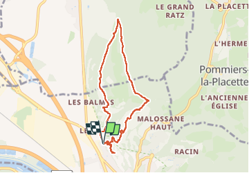

Length
8.5 km

Max alt
642 m

Uphill gradient
600 m
Km-Effort
16.5 km

Min alt
190 m

Downhill gradient
598 m
Boucle
Yes
Creation date :
2024-04-14 07:28:47.905
Updated on :
2024-04-14 16:08:56.478
6h29
Difficulty : Difficult

FREE GPS app for hiking
 SityTrail
IGN / Geographical institutes
SityTrail Plus
The world is yours!
About
Trail Walking of 8.5 km to be discovered at Auvergne-Rhône-Alpes, Isère, Voreppe. This trail is proposed by cousam.
Description
la montée après la grotte trou au loup au belvédère du Bourget très hard (trace Sombardier)
Photos


Positioning
Country:
France
Region :
Auvergne-Rhône-Alpes
Department/Province :
Isère
Municipality :
Voreppe
Location:
Unknown
Start:(Dec)
Start:(UTM)
705944 ; 5020254 (31T) N.
Comments