


Visite de Buno-Bonnevaux

mathis01
User
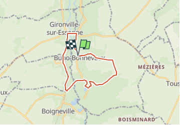

Length
11.1 km

Max alt
124 m

Uphill gradient
115 m
Km-Effort
12.7 km

Min alt
65 m

Downhill gradient
116 m
Boucle
Yes
Creation date :
2024-04-15 07:37:33.698
Updated on :
2024-05-19 15:52:05.47
2h52
Difficulty : Easy

FREE GPS app for hiking
 SityTrail
IGN / Geographical institutes
SityTrail Plus
The world is yours!
About
Trail On foot of 11.1 km to be discovered at Ile-de-France, Essonne, Buno-Bonnevaux. This trail is proposed by mathis01.
Positioning
Country:
France
Region :
Ile-de-France
Department/Province :
Essonne
Municipality :
Buno-Bonnevaux
Location:
Unknown
Start:(Dec)
Start:(UTM)
454667 ; 5356537 (31U) N.
Comments