


Roquebrune - Haute Rouquaire

GeorgesV.
User
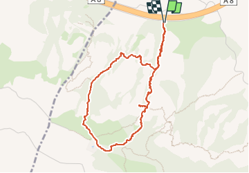

Length
4.8 km

Max alt
317 m

Uphill gradient
355 m
Km-Effort
9.5 km

Min alt
26 m

Downhill gradient
356 m
Boucle
Yes
Creation date :
2024-04-15 06:45:01.0
Updated on :
2024-04-15 10:17:25.964

FREE GPS app for hiking
 SityTrail
IGN / Geographical institutes
SityTrail Plus
The world is yours!
About
Trail of 4.8 km to be discovered at Provence-Alpes-Côte d'Azur, Var, Roquebrune-sur-Argens. This trail is proposed by GeorgesV..
Positioning
Country:
France
Region :
Provence-Alpes-Côte d'Azur
Department/Province :
Var
Municipality :
Roquebrune-sur-Argens
Location:
Unknown
Start:(Dec)
Start:(UTM)
306090 ; 4814514 (32T) N.
Comments