


chaucenne

micbesac
User

Length
14.6 km

Max alt
264 m

Uphill gradient
199 m
Km-Effort
17.3 km

Min alt
207 m

Downhill gradient
195 m
Boucle
No
Creation date :
2024-04-15 12:01:59.768
Updated on :
2024-04-15 15:43:12.028
2h46
Difficulty : Difficult

FREE GPS app for hiking
 SityTrail
IGN / Geographical institutes
SityTrail Plus
The world is yours!
About
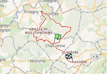
Trail Walking of 14.6 km to be discovered at Bourgogne-Franche-Comté, Doubs, Chaucenne. This trail is proposed by micbesac.
Positioning
Country:
France
Region :
Bourgogne-Franche-Comté
Department/Province :
Doubs
Municipality :
Chaucenne
Location:
Unknown
Start:(Dec)
Start:(UTM)
718956 ; 5241024 (31T) N.
Comments