


la Sauvié

34christophe
User
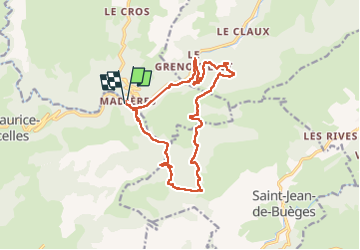

Length
17.2 km

Max alt
694 m

Uphill gradient
601 m
Km-Effort
25 km

Min alt
219 m

Downhill gradient
604 m
Boucle
Yes
Creation date :
2024-04-02 06:46:05.768
Updated on :
2024-07-06 17:18:00.462
4h54
Difficulty : Medium

FREE GPS app for hiking
 SityTrail
IGN / Geographical institutes
SityTrail Plus
The world is yours!
About
Trail Walking of 17.2 km to be discovered at Occitania, Gard, Rogues. This trail is proposed by 34christophe.
Description
u
Positioning
Country:
France
Region :
Occitania
Department/Province :
Gard
Municipality :
Rogues
Location:
Unknown
Start:(Dec)
Start:(UTM)
545354 ; 4855873 (31T) N.
Comments