


vers le Montahut

Mascart
User
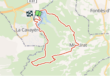

Length
10.4 km

Max alt
276 m

Uphill gradient
267 m
Km-Effort
13.9 km

Min alt
137 m

Downhill gradient
266 m
Boucle
Yes
Creation date :
2024-04-16 11:17:02.237
Updated on :
2024-04-16 16:14:10.016
2h45
Difficulty : Medium

FREE GPS app for hiking
 SityTrail
IGN / Geographical institutes
SityTrail Plus
The world is yours!
About
Trail Walking of 10.4 km to be discovered at Occitania, Aude, Carcassonne. This trail is proposed by Mascart.
Description
départ de la base de loisirs du lac de la Cavayère.
Positioning
Country:
France
Region :
Occitania
Department/Province :
Aude
Municipality :
Carcassonne
Location:
Unknown
Start:(Dec)
Start:(UTM)
452413 ; 4781299 (31T) N.
Comments