


La Soufrière

David25400
User GUIDE
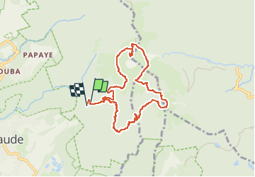

Length
12.7 km

Max alt
1455 m

Uphill gradient
832 m
Km-Effort
24 km

Min alt
818 m

Downhill gradient
868 m
Boucle
Yes
Creation date :
2024-04-16 13:57:02.546
Updated on :
2024-04-16 20:12:41.44
6h14
Difficulty : Medium

FREE GPS app for hiking
 SityTrail
IGN / Geographical institutes
SityTrail Plus
The world is yours!
About
Trail Walking of 12.7 km to be discovered at Guadeloupe, Unknown, Saint-Claude. This trail is proposed by David25400.
Photos


28 photos in total. Please click on a photo to see them all in the gallery.
Positioning
Country:
France
Region :
Guadeloupe
Department/Province :
Unknown
Municipality :
Saint-Claude
Location:
Unknown
Start:(Dec)
Start:(UTM)
641924 ; 1773178 (20Q) N.
Comments