


suuntoapp-Trekking-2024-04-04T07-16-09Z-route 2

ajd26
User
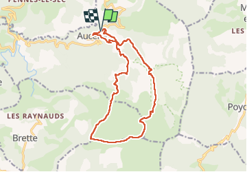

Length
17.5 km

Max alt
1598 m

Uphill gradient
985 m
Km-Effort
31 km

Min alt
721 m

Downhill gradient
985 m
Boucle
Yes
Creation date :
2024-04-17 08:48:05.0
Updated on :
2024-04-17 08:54:06.407
5h30
Difficulty : Medium

FREE GPS app for hiking
 SityTrail
IGN / Geographical institutes
SityTrail Plus
The world is yours!
About
Trail Walking of 17.5 km to be discovered at Auvergne-Rhône-Alpes, Drôme, Aucelon. This trail is proposed by ajd26.
Positioning
Country:
France
Region :
Auvergne-Rhône-Alpes
Department/Province :
Drôme
Municipality :
Aucelon
Location:
Unknown
Start:(Dec)
Start:(UTM)
686348 ; 4944116 (31T) N.
Comments