


2- Vion - Pont de l'Isère

v.hanosset
User
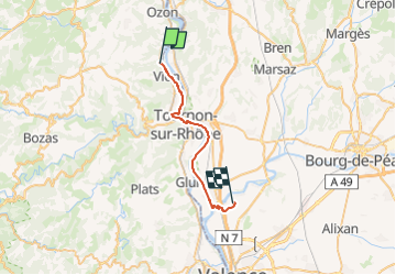

Length
24 km

Max alt
130 m

Uphill gradient
141 m
Km-Effort
26 km

Min alt
111 m

Downhill gradient
149 m
Boucle
No
Creation date :
2024-04-17 12:41:48.354
Updated on :
2024-04-17 12:43:02.761
1h34
Difficulty : Medium

FREE GPS app for hiking
 SityTrail
IGN / Geographical institutes
SityTrail Plus
The world is yours!
About
Trail Road bike of 24 km to be discovered at Auvergne-Rhône-Alpes, Ardèche, Vion. This trail is proposed by v.hanosset.
Positioning
Country:
France
Region :
Auvergne-Rhône-Alpes
Department/Province :
Ardèche
Municipality :
Vion
Location:
Unknown
Start:(Dec)
Start:(UTM)
641675 ; 4998044 (31T) N.
Comments