


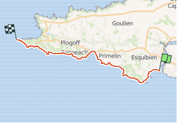
Audierne , Pointe du Raz

Axelloceane
User

Length
23 km

Max alt
66 m

Uphill gradient
336 m
Km-Effort
27 km

Min alt
0 m

Downhill gradient
326 m
Boucle
No
Creation date :
2024-04-17 08:19:43.561
Updated on :
2024-04-22 18:54:38.378
5h22
Difficulty : Difficult

FREE GPS app for hiking
 SityTrail
IGN / Geographical institutes
SityTrail Plus
The world is yours!
About
Trail Walking of 23 km to be discovered at Brittany, Finistère, Audierne. This trail is proposed by Axelloceane.
Description
départ du mât de Fenoux d' Audierne en suivant le balisage du GR 34 jusqu'à la pointe du Raz .
Photos


Positioning
Country:
France
Region :
Brittany
Department/Province :
Finistère
Municipality :
Audierne
Location:
Audierne
Start:(Dec)
Start:(UTM)
385062 ; 5318823 (30U) N.
Comments