


circuit des couas champagney

michelrenaud
User
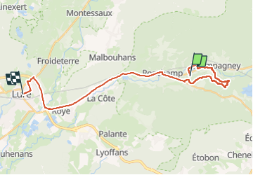

Length
25 km

Max alt
440 m

Uphill gradient
211 m
Km-Effort
28 km

Min alt
289 m

Downhill gradient
280 m
Boucle
No
Creation date :
2024-04-17 12:07:39.071
Updated on :
2024-04-17 15:13:32.967
3h04
Difficulty : Very difficult

FREE GPS app for hiking
 SityTrail
IGN / Geographical institutes
SityTrail Plus
The world is yours!
About
Trail Walking of 25 km to be discovered at Bourgogne-Franche-Comté, Haute-Saône, Champagney. This trail is proposed by michelrenaud.
Description
circuit des couas champagney
Positioning
Country:
France
Region :
Bourgogne-Franche-Comté
Department/Province :
Haute-Saône
Municipality :
Champagney
Location:
Unknown
Start:(Dec)
Start:(UTM)
324453 ; 5285388 (32T) N.
Comments